- S-76 Wilson Library
309 19th Ave. South
Minneapolis, MN 55455
(612) 624-4549
FAX: (612) 626-9353
e-mail: mapref@umn.edu

Atlas of Minnesota
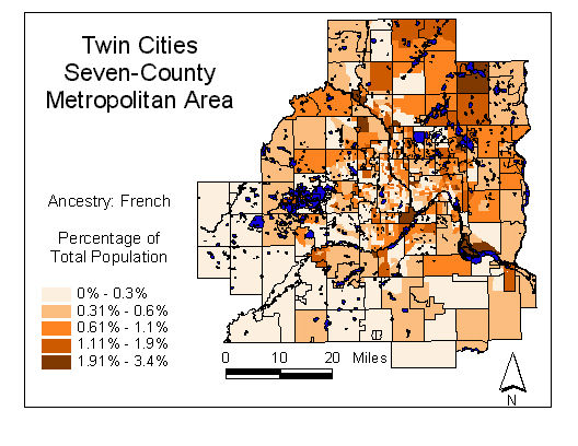 This map presents 1990 Census data by census tract for the Twin Cities Seven-County*
Metropolitan Area. In order to make the map easier to read, census tract
boundary outlines have been removed. For reference, MCD (city and town)
boundaries have been added.
Maps © copyright 1997 by Brent Allison.
All rights reserved.
Web Page © copyright 1997 by the
Regents of the University of Minnesota.
All rights reserved.
Map image courtesy of ESRI, Inc.
Map data courtesy of Wessex, Inc. based
on U.S. Bureau of the Census, 1990
This map presents 1990 Census data by census tract for the Twin Cities Seven-County*
Metropolitan Area. In order to make the map easier to read, census tract
boundary outlines have been removed. For reference, MCD (city and town)
boundaries have been added.
Maps © copyright 1997 by Brent Allison.
All rights reserved.
Web Page © copyright 1997 by the
Regents of the University of Minnesota.
All rights reserved.
Map image courtesy of ESRI, Inc.
Map data courtesy of Wessex, Inc. based
on U.S. Bureau of the Census, 1990
*Anoka, Carver, Dakota, Hennepin, Ramsey, Scott,
and Washington Counties
Last updated 4/16/08
Web page created by Brent
Allison
Maintained by John R. Borchert Map Library staff
http://map.lib.umn.edu/bessie/
